


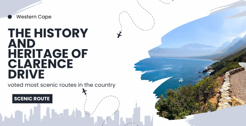
The History and Heritage of Clarence Drive: South Africa’s Most Scenic Coastal Route
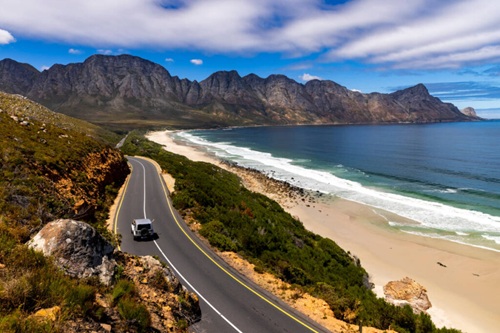
South Africa is a land of sweeping coastlines, towering mountain ranges, and rugged landscapes, many of which have only recently become accessible thanks to engineering feats like Clarence Drive. This iconic stretch of road winds its way along the False Bay coastline between Gordon’s Bay and Rooi-Els in the Western Cape. Today, it is known as one of the most scenic routes in the country, drawing tourists, cyclists, and road trip enthusiasts from all corners of the globe.
But Clarence Drive is more than just a pretty road. It has a rich and fascinating history that reaches back into the early settlement of the Cape and tells a tale of exploration, wartime necessity, and visionary development. This article takes an in-depth look at the history of Clarence Drive—from its earliest days as inaccessible terrain to the world-class route it is today.
The Land Before the Road
Before Clarence Drive was built, the coastal region between Gordon’s Bay and Rooi-Els was remote and largely inaccessible. In the seventeenth and eighteenth centuries, when European settlers first arrived in the Cape, the Hottentots Holland Mountains posed a formidable natural barrier between Cape Town and the Overberg.
To reach the Overberg, settlers initially followed ox-wagon trails over the Gantouw Pass, a route originally used by the Khoi people and migrating wildlife. This pass eventually became known as the Old Wagon Road and later evolved into Sir Lowry’s Pass. While functional, it was treacherous and time-consuming. The idea of a coastal route was not seriously considered until much later due to the steep cliffs and unstable geology of the shoreline between Gordon’s Bay and Rooi-Els.
Even in the early 1900s, settlements in the Hangklip and Betty’s Bay area had to be accessed by detouring over the mountains and down towards the sea. Supplies were delivered via long ox-wagon journeys, and the area remained a quiet, underdeveloped part of the Cape.
The Vision of Jack Clarence
The transformation of this isolated stretch of coastline can be largely credited to one man: Gerald “Jack” Clarence. A Cape businessman with a strong vision for the development of the region, Clarence was one of a trio of developers who saw potential in the untouched land between Gordon’s Bay and Hangklip.
In the 1930s, Clarence, together with conservationist Harold Porter and property developer Arthur Youlden, began purchasing tracts of land in the area. Youlden established the town of Betty’s Bay, naming it after his daughter. Harold Porter would later donate large parts of his land to conservation causes, creating the foundation for what would become the Harold Porter National Botanical Garden.
Jack Clarence, however, saw that access was the key to unlocking the region’s potential. He began lobbying for a road that would hug the dramatic cliffs of the False Bay coastline and connect Gordon’s Bay directly with Rooi-Els. At the time, this was considered by many to be an unrealistic goal. The terrain was steep, rocky, and dangerous, and engineering such a road would be expensive and technically demanding.
Nonetheless, Clarence persisted. He understood that tourism, property development, and conservation could all benefit from easier access to the area. His determination paid off when, during the 1940s, the project received an unexpected boost from an unlikely source: World War II.
Built by War: The Role of World War II
The Second World War had a significant and direct impact on the development of Clarence Drive. As the threat of enemy submarines loomed off the South African coast, the government realised that they needed radar installations along the Cape coastline to monitor naval traffic and protect shipping routes.
One such radar station was to be constructed near Hangklip, high up on the mountainside overlooking False Bay. For this purpose, a road was needed. The South African military approved the construction of a coastal route from Gordon’s Bay to Rooi-Els, aligning almost perfectly with Jack Clarence’s original vision.
But building a road along the cliffs during wartime was no small task. South Africa had limited resources and manpower due to the war effort. Fortunately, a solution was found in the form of Italian prisoners of war who had been captured in North Africa and transported to camps in South Africa.
These Italian POWs were housed in barracks in the area now known as Glen Craig, near Betty’s Bay. Under supervision, they were employed in the construction of the coastal road. Using picks, shovels, explosives, and grit, the prisoners carved the road out of the mountainside. It was slow, dangerous work, but the men performed it well. The quality of their craftsmanship can still be seen today in the original stone retaining walls and bridges that remain intact.
The construction of Clarence Drive was both a military necessity and a civilian blessing. By the end of the war, the road was complete, opening up the Hangklip coast to the rest of the Cape.
Post-War Development and Recognition
After the war, the road became known as Clarence Drive, in honour of the man who had fought tirelessly for its construction. While it was initially a gravel road, its importance quickly grew. It became a vital route for locals and an attractive drive for visitors seeking to experience the raw beauty of the Cape coast.
Over the decades, the road was gradually upgraded. In the 1990s, major reconstruction and safety improvements were undertaken. Hairpin bends were widened, guardrails were added, and viewing sites were created to allow drivers to stop and appreciate the views without obstructing traffic. The newly resurfaced and improved road was officially reopened in 1998 by Premier Gerald Morkel.
Today, Clarence Drive is not just a practical route. It is a destination in its own right, known for its dramatic vistas, towering cliffs, and panoramic views of False Bay. The road winds through no fewer than seventy-seven bends over its 22-kilometre stretch, offering endless photo opportunities and lookouts.
Environmental Significance
One of the most remarkable aspects of Clarence Drive is the natural beauty it reveals. Much of the route runs through the Kogelberg Biosphere Reserve, one of the most biologically diverse areas in the world. Often called the heart of the Cape Floral Kingdom, the Kogelberg region boasts thousands of species of fynbos, many of which are found nowhere else on Earth.
Travelers along Clarence Drive also pass near the Harold Porter National Botanical Garden, which preserves both cultivated and wild examples of the region’s unique flora. The area is also home to baboons, dassies, porcupines, and a wide range of bird species.
Despite its development, Clarence Drive has managed to maintain a balance between human access and ecological preservation, thanks to strict environmental controls and the awareness of conservationists who continue to advocate for the area’s protection.
A Treasured Road
Clarence Drive is loved not only for its beauty but also for its history. It is a road born out of vision and forged by the hardships of war. It is a reminder that human determination, even during times of conflict, can result in something of lasting value.
Many locals consider it the most beautiful drive in the country. Visitors often describe it as unforgettable, not only for the scenery but for the sense of serenity and grandeur it imparts. Whether shrouded in mist or basking in golden sunlight, Clarence Drive offers a visual and emotional experience like few others.
It is also a favourite among motorcyclists and cyclists, though the route must be treated with caution. The road’s curves and narrow shoulders can be dangerous, especially when wet or during windy conditions. Road users are advised to drive slowly, respect other vehicles, and stop only at designated pull-offs.
The story of Clarence Drive is one of perseverance, creativity, and adaptation. From the early vision of Jack Clarence to the hard labour of Italian POWs, and from wartime urgency to peacetime leisure, the road has evolved into a symbol of natural harmony and historical significance.
It is a shining example of how human enterprise, when guided by vision and necessity, can enhance rather than diminish the landscape. Clarence Drive is not just a route between two towns—it is a living museum, a testament to South Africa’s past, and a monument to its natural splendor.
FAQ: Clarence Drive History and Travel
What is Clarence Drive and where is it located?
Clarence Drive is a scenic coastal road in the Western Cape, South Africa. It stretches approximately 22 kilometres between Gordon’s Bay and Rooi-Els, following the eastern shoreline of False Bay.
Who was Clarence Drive named after?
Clarence Drive was named after Gerald “Jack” Clarence, a Cape entrepreneur who played a key role in developing the Hangklip coast and championed the idea of building a road to connect the area to Gordon’s Bay.
When was Clarence Drive built?
Construction of Clarence Drive began during World War II in the early 1940s and was completed by the end of the war. The road was built primarily to provide military access to radar installations near Hangklip.
Who built Clarence Drive?
Clarence Drive was constructed with the help of Italian prisoners of war (POWs) who were captured during World War II and brought to South Africa. They built the road under supervision while stationed in the region.
Why was Clarence Drive originally constructed?
The road was built during World War II for military reasons, specifically to allow access to radar stations monitoring enemy naval activity. It later became essential for civilian transport and regional development.
Is Clarence Drive a dangerous road?
While beautiful, Clarence Drive includes many sharp bends and narrow sections. Drivers should proceed with caution, especially during rainy or windy conditions. There are designated viewing areas for safe stops.
Is Clarence Drive part of a nature reserve?
Yes, much of Clarence Drive runs through the Kogelberg Biosphere Reserve, which is part of the Cape Floral Kingdom. It is considered one of the most botanically diverse areas in the world.
What towns are connected by Clarence Drive?
Clarence Drive connects the coastal town of Rooi-Els to Gordon’s Bay, providing access to other towns such as Betty’s Bay, Pringle Bay, and Kleinmond along the R44.
Are there places to stop along Clarence Drive?
Yes, Clarence Drive includes multiple official viewpoints and pull-offs where visitors can enjoy panoramic views of False Bay and the surrounding mountains. These are ideal for photography and picnics.
Can cyclists use Clarence Drive?
Cyclists frequently use Clarence Drive, but they should exercise caution due to traffic, sharp turns, and the lack of a dedicated cycling lane. Early morning rides are usually safer and quieter.
How long is Clarence Drive?
Clarence Drive, also known as the R44, is a scenic coastal drive that runs between Gordon’s Bay and Rooi-Els, South Africa. It is a 22 km route that offers panoramic views of False Bay, the coastline, Table Mountain, and parts of the Cape Peninsula.